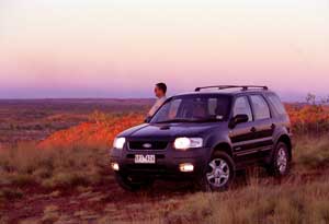
Billed and packaged as the "reef to outback" route, the Overlander's Highway encompasses many of the most enduring features of the Australian landscape. Story
and Photos by Roderick Eime From the sparse wilderness of the central Australian desert to the idyllic tropics adjacent the Great Barrier Reef, the Barkly and Flinders Highways (marketed together as the Overlander's) weave many divergent, yet complementary features of our great country together into a rich and vivid tapestry. It's a drive like many others, weaving through both bustling centres and sleepy hamlets, yet delivering the inquisitive traveller rewarding snapshots of life in the true Australian frontier and a very personal experience. The journey is easily tackled in either direction, and may be confidently completed in virtually any vehicle. As with many of the drives in this publication, a 4WD will maximise your enjoyment of this trek, enabling you to explore the many enticing sidetracks you'll find along the way. Of course, when venturing off the tarmac, be sure to follow sensible precautions. Generally,
the main route is in good repair, without any notable hazards. At
time of writing, vigorous road works were in progress around the
Mount Isa/Cloncurry region. The low, narrow bridges so often inundated
by the region's notorious floods are being bypassed with upgraded
structures, much to the relief of frustrated locals. The flimsy
ribbon of highway between Mount Isa and Camooweal is the only real
area of concern. Long overdue for rebuilding, this forlorn stretch
requires caution. When encountering on-coming heavy traffic here,
it is wise to slow right down and pull off the road completely so
the big rigs aren't forced into the gravel on the shoulder. You'll
make up for any lost time with a saved windscreen! TENNANT CREEK TO CAMOOWEAL (450kms) The cool sunny weather during the middle of the year makes this drive one of the most pleasant you'll find anywhere. The bitumen from Tennant Creek to the Queensland border is flawless, and is the perfect spot to make up a little time on the unrestricted NT roads. Often overlooked in flashy Northern Territory promotions, Tennant Creek is a true outback town, literally carved out of the red earth by tenacious gold miners over nearly 150 years ago, and a perfect location to base yourself for a few days to explore the many nearby attractions. There are several quality motels, a three-star caravan park, the award-winning Margot Myles restaurant, and self-contained units at the Desert Sands that are ideal for larger groups and families. The laundry facilities are certainly handy if you finish your journey here!
Buy your fuel and provisions in town, as the price jumps at Three Ways and doesn't come down until Mount Isa. About 190kms east, the Barkly Homestead Wayside Inn is a handy rest point with leafy picnic grounds, amenities and somewhere to park your caravan overnight. Thereafter it's an effortless, if somewhat unremarkable drive to Camooweal. CAMOOWEAL to MOUNT ISA (190 Kms) Despite its location on a national highway, Camooweal retains all the hallmarks of the archetypical remote outpost - tumbledown cottages, verandahs and lots of tin and corrugated iron. The recently rebuilt bridge over the often-flooded Georgina River could make it less of one. That same river hosts several superb billabongs, teaming with waterbirds, only a short distance from town. There's room for a caravan and is a great photo spot at sunset. Accommodation is a bit patchy and in high demand, so book ahead. There are a few clean cabins behind the pub and at the Caravan Park/Service Station, but little else. Pop in to Freckleton's Store for an authentic taste of outback heritage. There's a small, but well-stocked information bureau just off the main road and is staffed by Drover's Camp Association volunteers, so won't always be open. If the weather is dry, ask about a drive out to the Camooweal Caves National Park. Always check first, because the road gets chopped up after rain and is not always passable - even in a 4WD. It's a slow, rough 40+km round-trip, but you'll be rewarded with some unique fauna like ghost bats, owls and ridge-tailed monitors. Camping facilities are provided. The highway down to Mount Isa is a relic of urgent wartime necessity, and one wonders how it's lasted this long with such little maintenance. Give the road trains plenty of room. Alternatively, the northern Gunpowder/Kajabbi loop offers a respite from the over-beaten track and an excuse to visit the quirky Kalkadoon Pub, man-made Lake Julius or mythic Battle Mountain. In fact, you could bypass Mount Isa altogether and make a beeline for Cloncurry via Qamby. The substantial mining town of Mount Isa is the largest population centre you'll visit along the route. The Riversleigh Centre is an expansive and comprehensive facility that serves as both museum and information point. You can research tourist attractions anywhere in the wider region including national parks, accommodation, tours and souvenirs. Fossils are big business almost all the way through to the coast, so you'll see plenty about them and the prehistoric monsters that spawned them. Unlike the personal attention you'll get at most other points along the route, you'll need to line up with coach parties and tour groups in the busy complex, so have a look, get what you need and move along. Accommodation choices abound in Mt Isa. You can pull up at one of the spotless caravan parks like the 31/2 star Sunset Caravan Park or even stay out of town at a real ranch like Ron and Joan Croft's West Leichhardt Station, an option that really gives you an insight into working life in the bush. MOUNT ISA TO JULIA CREEK (256 KMS)
120 kms east of Mount Isa, is yet another town born on the wave of an ore boom. This time it was copper in 1867, but Cloncurry boasts greater feats. John Flynn established the Royal Flying Doctor Service there in 1928 and the concept of what is now Qantas sprung from a broken axle in the Cloncurry River. Wander amongst the pioneer display in Mary Kathleen Memorial Park that includes items, vehicles and buildings removed from the deserted uranium mine once located half-way to Mount Isa. The RFDS is celebrated here with an excellent memorial and museum at John Flynn Place. Traffic tapers off markedly once you pass the Landsborough Highway (Matilda) intersection 14 kms out of town. Some older tourist guides refer to this stretch of the Flinders Highway as the Dinosaur Highway and one or more of the frequent trains traversing the Townsville-Mount Isa line directly to the south'll escort you. As you leave the Selwyn Ranges, the countryside begins to shed its low, woody vegetation in favour of vast grassy plains of infamous black soil - stuff to stay well out of when wet. Julia Creek appears almost out of nowhere and offers itself up as an inviting watering hole and usefully located waypoint on our trip.
JULIA CREEK TO HUGHENDEN (256 kms) Continuing east, we enter the well-promoted dinosaur fossil country, home of the Muttaburra- and Kronosaurus. To drive home the point, full size replicas of each patrol Hughenden and Richmond respectively. Richmond's Kronosaurus Korner recently expanded to include several new exhibits and you could get more than your fill of fossils in just one visit. Once a Cobb and Co staging point, you can see a restored coach and memorabilia in Lions Park, just up the bougainvillea-lined street.
Before you head out, visit the Dinosaur Display and Information Centre, well marked in Gray Street. |
 For
a full account of the all points of interest, you must visit the
 On
this next leg, you'll cross a series of brand new bridges still
under construction as we passed through. These bridges mean travel
along this section of the Flinders Highway will be much less fraught
with hazards than ever before. This reengineering allows greater
freedom from worry for both holidaymakers and professional drivers
alike.
 The
Julia Creek Hotel, locally referred to as the "top pub",
provides clean beds, huge steaks and cold beer in an unpretentious
outback pub atmosphere. Closer investigation will turn up some unusual
sights in the region. Sedan Dip, about 80 kms along the Bourke and
Wills road is not much more than a water hole and racetrack that
hosts both a fishing tournament and a country race meeting each
year. Julia Creek too stages a nationally recognised triathlon and
is the sort of friendly little village you can't help but get intimate
with.
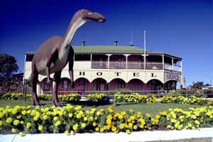
 Hughenden
is just over 100 kms away and also plays heavily on its fossil attractions,
evidenced by giant "Hughie" perpetually on his way home
from the aptly named Grand Hotel in Stansfield Street. Hughenden
is perfectly placed to serve as a base for exploration of the wider
region, including the "must see"
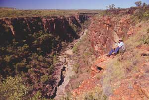
  Access
to the park is via a short 30 km drive north through heavy basalt
formations along the Kennedy Development Road where you can camp
cheaply near the Pyramid Lookout in the specially equipped area.
Sprightly visitors can enjoy superb bushwalks down to the valley
where richly textured rocks border the headwaters of the great Flinders
River. Bring your camera as the views are quite breathtaking.